
Introduction On The Mekong River
Picture of the route of the Mekong River:
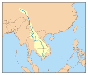
Source:
http://upload.wikimedia.org/wikipedia/commons/e/e4/Mekong_River_watershed.png
The Mekong River is one of the world’s major rivers. It is the 12th-longest river in the world and 7th longest in Asia stretching within the six countries of China, Myanmar, Lao PDR, Thailand, Cambodia and Viet Nam. It discharges at 475 km³ of water annually and is estimated with the length of 4,350 km long, draining an area of 795,000 km².
There are many tributaries that flows into the Mekong River. The following are the names of the tributaries with the indication of the country they belong to:
- Ing River (Thailand)
- Ruak River (Thailand)
- Mun River (Thailand)
- Chi River (Thailand)
- Dom Noi River (Thailand)
- Kok River (Thailand)
- Lam Ta Klong River (Laos/Thailand)
- Nam Ou (Laos)
- Nam Ngum (Laos)
- Sebanghiang (Laos)
- Sekon River (Laos, Cambodia, Vietnam)
- Sesan River (Cambodia)
- Ea H'leo River (Cambodia)
- Tonlé Sap River (Cambodia)
- Srepok River (Cambodia-Vietnam)
- Krong No River (Vietnam)
- Krong Ana River (Vietnam)
- Bassac River (called Hau River in Vietnam)
- My Tho River
- Ham Luong River
- Co Chien River
- Ba Lai rivers
Description And Physical Features Of The Mekong River
Parts of the Mekong River:


Source:
http://cantho.cool.ne.jp/mekong/outline/mekong_river_e.html
The overall pictures of the Mekong River Basin:


Source:
http://www.mrcmekong.org/flood_report/2005/the_flood1.htm
http://www.vnbaolut.com/MekongRiverBasin_RS.jpg
From its river source, the Mekong River stretches about 4,800 km to the South China Sea, draining a total catchment area of approximately 795,000 km². The Greater Mekong can be divided into two parts: the Upper Basin in Tibet and China, where the river is called Lancang Jiang, and the Lower Mekong Basin from Yunnan downstream from China to the South China Sea. It flows for almost 2,200 km from its river source and decreases in altitude by nearly 4,500 km before it enters the Lower Basin, where the borders of Thailand, Lao PDR, China and Burma come together in the Golden Triangle.
Picture of the Golden Triangle:
Source:
http://www.flickr.com/photos/bhojman/2461402050/
Downstream from the Golden Triangle, the river flows for a further 2,600 km through Lao PDR, Thailand and Cambodia before entering the South China Sea through a complex delta system in Viet Nam. The Upper Basin makes up 24% of the total area and contributes 15% to 20% of the water that flows into the Mekong River where the catchment here is steep and narrow.
Major tributary systems develop in the Lower Basin. These systems can be separated into two groups: tributaries that contribute to the major wet season flow, and tributaries that drain low relief regions of lower rainfall. The first group are the left bank tributaries that drain the high-rainfall areas of Lao PDR. The second group are those on the right bank, mainly the Mun and Chi Rivers that drain a large part of Northeast Thailand.
Mekong and its tributaries:

Source:
http://upload.wikimedia.org/wikipedia/commons/d/d6/Mekong_system_color.png
As the Mekong enters Cambodia, over 95% of the flows have already joined the river. From here on downstream, the terrain is flat and water levels are flow volumes which determine the movement of water across the landscape. During the flood months, water flows up the Tonle Sap to the Mekong River mainstream into the lake. As the water level decreases in the mainstream in the later months, water flows out of the Tonle Sap down into the Mekong mainstream.
The Great Lake on the Cambodian floodplain is the largest body of fresh water in Southeast Asia and forms one of the key features of the lowlands. As stored water flows out of the lake back to the mainstream during the dry season, the low flows in the Mekong are increased.
Location of the Mekong Delta region within Vietnam:
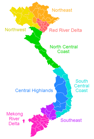
Source:
http://upload.wikimedia.org/wikipedia/commons/d/de/VietnameseRegions.png
The Mekong Delta is the region in southwestern Vietnam where the Mekong River approaches and empties into the sea through a network of distributaries. Its catchment area is very unstable due to lack of proper survey especially in the upstream mountainous area and in the Mekong Delta of which watershed is obscure. Hence, each documents has each values on catchment area or other figures like stream length is imaged with approximately the size of 800,000km².
The Mekong Delta from space:

Source:
http://upload.wikimedia.org/wikipedia/en/0/03/Mekong_delta.jpg
The area of the Mekong Delta is a home to a large numbers of rice fields. In 2004, in large part thanks to the Mekong Delta, Vietnam was the third largest exporter of rice globally after Thailand and India. In 2003, Vietnam was the world's second largest exporter of rice. Additionally, the region is a home to large exports of basa fish, tra fish and shrimp, much of which is exported. The main delta is made up of a vast triangular plain which is lower than five metres above sea level, large areas of which are flooded every year.
Levees were built hundreds of years ago along some of the main natural channels. Hydrology is not only dominated by the rivers but also by the tide, which has a large expansion in the dry season and can also slow down the drainage of the river during heavy flood periods, mainly downstream.
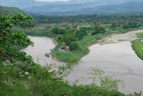
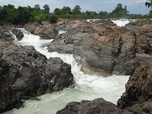
Pictures of the waterfalls and rapids in Mekong:
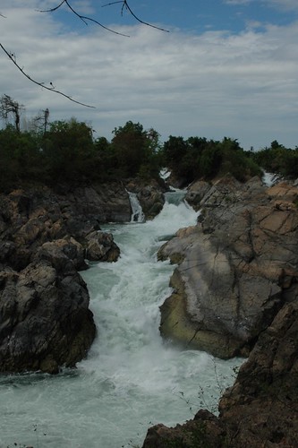


Source:
http://www.flickr.com/photos/kamaski/2326248555/
http://www.flickr.com/photos/jimcowdrill/430089553/
http://www.flickr.com/photos/andrea-tim2/160711574/
http://www.flickr.com/photos/big_tex/363596244/
http://www.flickr.com/photos/kamaski/2323649385/
Social And Political Background Of River
The difficulty of navigating the river has meant that it has divided, rather than united, the people who live near it. The earliest known settlements date to 2100 BCE, with Ban Chiang being an excellent example of that early Iron Age culture. The earliest recorded civilisation was the 1st century Indianised-Khmer culture of Funan, in the Mekong Delta. Excavations at Oc Eo, near modern An Giang, have found coins from as far away as the Roman Empire. This was succeeded by the Khmer culture Chenla state by around the 5th century. The Khmer empire of Angkor was the last great Indianised state in the region. From around the time of the fall of the Khmer empire, the Mekong was the frontline between the emergent states of Siam and Tonkin (North Vietnam), with Laos and Cambodia, then situated on the coast, torn between their influence.
A map of 1715, incorrectly showing the Chao Praya river as a branch of the Mekong:

Source:
http://upload.wikimedia.org/wikipedia/en/a/aa/Mekongmap1715.jpg
The first European to encounter the Mekong was the Portuguese Antonio de Faria in 1540; a European map of 1563 depicts the river, although even by then little was known of the river upstream of the delta. European interest was sporadic: the Spaniards and Portuguese mounted some missionary and trade expeditions, while the Dutch Gerrit van Wuysthoff led an expedition up the river as far as Vientiane in 1641-42.
The French took a serious interest in the region in the mid-19th century, capturing Saigon, from Vietnamese invaders, in 1861, and establishing a protectorate over Cambodia in 1863.
The first systematic exploration began with the French Mekong Expedition led by Ernest Doudard de Lagrée and Francis Garnier, which ascended the river from its mouth to Yunnan between 1866 to 1868. Their chief finding was that the Mekong had too many falls and rapids to ever be useful for navigation. The river's source was located by Pyotr Kuzmich Kozlov in 1900.
The members of the French Mekong Expedition of 1866:

Source:
http://upload.wikimedia.org/wikipedia/en/8/88/Mekongmembersangkor.jpg
From 1893, the French extended their control of the river into Laos, establishing French Indochina by the first decade of the 20th century. This lasted until the First and Second Indochina Wars ended French and American involvement in the region.
After the Vietnam War, the tensions between the U.S.-backed Thai government and the new Communist governments in the other countries prevented cooperation on use of the river.
Uses Of The Mekong River
Wildlife
There is much wildlife along the Mekong River as it flows through the rainforests. Many of its plants and animals are found nowhere else in the world. Most of the Mekong River Basin is unspoil because there has not been much industrial development. Therefore, it plays an important role for the wildlife.
Dams
There are only a few dams along the Mekong. However, there are plans to built new dams so that people can control the river better during the dry and flood seasons. The new dams will also mean that people will be able to generate electricity from the dams, hydroelectric power.
However, there are problems with building the dams. There will be damage to the environment and fishing areas in the delta. Many people will be forced to move out of their homes close to where the dams are built. There may also be more floods because the river is restricted in its flow. There may also be a loss in biodiversity cause by the damage of the environment.
Flood
The Mekong River floods in the delta region every year during the monsoon season. The delta is submerged under water. The sediment from the flood makes the soil fertile and rich with nutrients. Algriculture can also take place and the farmers' cultivated crops will grow healthily.
Crops of rice the Mekong rice bowl region:

Tourism And Leisure Activities
Tourism is important to the Mekong. There are many different two or three day cruises along the Mekong. Some cruises visit the mountainous areas north of Laos, other cruises travel round the 4000 islands.
One of the leisure activities held in the Mekong Delta:

Source:
http://graphicslib.viator.com/graphicslib/2514/SITours/mekong-delta-cruise-private-tour-in-ho-chi-minh-city-1.jpg
The Mekong River also provides opportunities for leisure activities such as whitewater rafting, crusing and relaxation as they are scenic and exciting. They can bring in income from tourism for locals and helps to improve the economic condition of the country.
Transportation
The Mekong River is a vital river that provides a major transportation link from north to south. Therefore, trade can be develop along the river. An example of the Mekong River is that it serves as a new oil-shipping trading route between Chiang Saen Port by the bank of the Mekong in Chieng Rai Province, Thailand and Yunnan in Southern China.
A ferry in Mekong Delta region, Southern Vietnam:

Source:
http://www.scandasia.com/php/news_images/full_news_1743.jpg
Water
The Mekong River also provides an important source of water for domestic use, as well as for serves an important role for living things.
Mining
The mining for minerals and sand, which are available in the Mekong River, provides a source of income for locals.
However ..
The Mekong River may also do harm to man too. In times of heavy and prolonged rain, the river channels may be unable to accommodate the sudden increase in the water volume, causing the river to overflow their river banks and floods to occur.
One of the floods caused by the water of the Mekong River:

Source:
http://news.bbc.co.uk/olmedia/925000/images/_927778_mekong300.jpg
When this occurs, it damages properties, transport links, crops and kills lives as well. Millions of dollars have to be pumped into the restoration works. Floods also increase the risk of water-borne diseases, like the leptospirosis, caused by the exposure to water contaminated by urine of infected animals, as flooded sewage treatment plants contaminate water. Mosquito-borne illnesses like dengue and malaria and likely too.
Reflection ..Now, I would like to share with you a video clip uploaded by someone on the internet about his/her Mekong Cruise.
It is truly pleasurable doing this Geography assignment as it had benefited me a lot in the process of completing it. I had learnt some of the amusing facts about the Mekong River, for example, how huge the river actually is, and the interesting names given to some parts of the river, like the Golden Triangle.
When I first got to know about this assignment, I carried a negative attitude towards the assignment. In the process of doing it, some information could not be found on the internet and I was getting furious with the assignment. However, I managed my impulsivity and persisted in finishing my work.
I had reponded with wonderment and awe to the questions given in the assignment, as well as remaining open to continuous learning, not only to the Mekong River, but to other rivers, such as the Nile River as well. If I were to come across any news, articles or attracting facts about rivers, I would certainly share them with the others. :D
Source:
http://www.youtube.com/watch?v=ktW-o7c2PlI&eurl=
Enjoy!